


Fermer05
-
Posts
38 -
Joined
-
Last visited
Content Type
Profiles
Forums
Events
Posts posted by Fermer05
-
-
Why is not tidal current used to move ships from east to west.
0 -
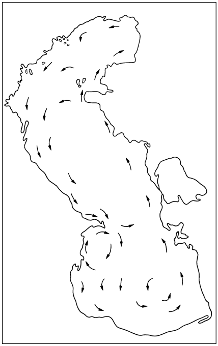
Waters of lakes, seas and oceans of the northern hemisphere rotate counterclockwise, and the waters of the southern hemisphere rotate clockwise, forming giant whirlpools.
The main reason for the rotation of the whirlpools are, local winds, flowing into the seas and oceans of the river and the deflecting force of Coriolis.
And the higher the speed of the winds, the higher the rotation speed of the whirlpools, and as a consequence, the higher the centrifugal force of the whirlpools, thereby raising the level of the waters of the seas and oceans.
And the lower the rotation speed of the whirlpools, the lower the water level of the seas and oceans ..The speed of the currents along the perimeter of the seas and oceans is not the same everywhere and depends on the depth of the coast.
In the shallow part of the seas and oceans, the current moves rapidly, and in the deep-water part of the seas and oceans the current moves slowly.Seasonal water level rise is not observed throughout the coast of the seas and oceans, but only in those coasts where the high angular velocity of the currents and as a consequence, the high centrifugal force of the water. (Centrifugal force F = mv2 / r).
On the rectilinear coasts, where the currents do not have angular velocity, the water level does not increase.The waters of the Gulf of Finland rotate counter-clockwise, forming a whirlpool in the form of an ellipse.
And when the seasonal south-west winds untwist the whirlpool to 5 km / h, the centrifugal force of the whirlpool increases, so that the water level rises to 30 cm on the eastern coast of the Gulf of Finland.
A similar scheme of seasonal water level rise is observed in all lakes, seas and oceans ..The average depth of the Gulf of Finland is about 50 meters, on the east coast about 5 meters, in the west of the bay about 100 meters, for this reason, on the eastern coast of the Gulf of Finland, the linear and angular velocity of the currents is much higher (by how much less the depth of the coast, ) ..
In the Gulf of Finland, seasonal water level rise has two peaks: in August-September, and in December-January and coincide with the season of south-west winds.
The current velocity in the Gulf of Finland reaches from 2 to 17 km / h, and the maximum current speed on the Earth reaches 30 km / h, the wind speed is more than 100 km / h.
http://goo.gl/eYVTo6
http://esimo.oceanography.ru/esp1/index.php?sea_code=1§ion=6&menu_code=1734The waters of the Caspian Sea rotate counter-clockwise, forming a whirlpool in the form of an ellipse.
And when the seasonal winds and flood river Volga unleash the whirlpool, the centrifugal force of the whirlpool increases, due to which, on the northern coast of the Caspian Sea, the water level rises to 1 meter.The average depth of the Caspian Sea is about 200 meters, on the northern coast about 5 meters, on the southern coast about 700 meters.
Due to this, in the north of the Caspian the current speed rises from 1 to 10 km / h.
In the Caspian Sea, the peak seasonal increase in water levels is observed in June and August and coincides with the season of winds and the flood of the Volga River.
During the drought over the Volga river basin, the level of the Caspian Sea does not increase.
http://tapemark.narod.ru/more/06.png
http://goo.gl/47tXq2During the season of the western winds, the current velocity along the Murmansk coast of the Barents Sea rises to 5 km / h, due to which the seasonal rise in the water level reaches 0.5 meters.
The maximum level values are observed in October-November minimum in April-May.
http://proznania.ru/?page_id=2353In the Bay of Bengal in the season of monsoon winds, the whirlpool speed rises to 10 km / h, due to which, the seasonal rise in water level reaches 1.2 meters.
http://www.aziya-tur.ru/bengal'skii-zaliv.phpSeasonal changes in the level of the Sea of Okhotsk are 0.2-0.5 m. The highest levels are observed in November-January, the smallest in March-April.
http://parusa.narod.ru/bib/books/fareast/1406-1.htmSeasonal increase in the level of the Black Sea (up to 40 cm) is most pronounced in the southeastern part of the sea, where in summer the angular velocity of the currents reaches a maximum value.
http://tapemark.narod.ru/more/07.htmlThe assumption that the cause of seasonal water level rise may be atmospheric pressure, river runoff, temperature difference and water salinity does not stand up to criticism, these factors can increase the water level by several cm, but not more.
Cyclones moving above the surface of the sea from west to east at a speed of up to 40 km / h can increase sea level for several days by untwisting the whirlpool.
http://www.okeanavt.ru/tainiokeana/1066mifosrednemurovne.html
The presented theory can be easily verified by the connection between the velocity of currents and the sea level and the oceans.
(Drawing on a map of depths and currents, seas and oceans).
Continuation: Forum NIAS MEPhI
https://mephi.ru/communication/forum/talk/forum13/topic5498/messages/0 -
04.04.2018 в 18:51, студент сказал:
Вы делали претензии, которые в корне противоречили традиционному мышлению о приливах. .
If, the tidal hump on Earth was created by the Moon - that would not be an ellipse but a "drop". (The force of gravity is added, not compensated).
What prevents a drop of water hanging on an apple, create two tidal hump?0 -
Follow the link, there are answers to all the questions, find the error, I will be very grateful if you put me on the right path. I do not want to waste my time on delusions.
http://www.spbgu.ru/forums/index.php?s=7508ff0db43c4d8fd53c510b9451235a&showtopic=53992-1 -
The vortex theory of tides can be easily verified by the connection between the height of the tidal wave and the rotation speed of the whirlpools.
The list of seas with an average swirl speed of more than 0.5 km / h, and an average tidal wave height of more than 5 cm:
Irish Sea, North Sea, Barents Sea, Baffin Sea, White Sea, Bering Sea, Sea of Okhotsk, Arabian Sea, Sargasso Sea, Hudson Bay, Maine Bay, Gulf of Alaska. and so on.
The list of seas with an average swirl speed of less than 0.5 km / h, and an average tidal wave height of less than 5 cm:
The Baltic Sea, the Greenland Sea, the Black Sea, the Sea of Azov, the Caspian Sea, the Chukchi Sea, the Kara Sea, the Laptev Sea, the Red Sea, the Marmara Sea, the Caribbean Sea, the Sea of Japan, the Gulf of Mexico, etc.
Note: The height of the tidal wave (soliton) and the amplitude of the tides is not the same.0 -
On 22.1.2017 at 1:20 PM, Fermer05 said:
The tides are the result of the rotation of the Earth and the whirlpools.
There is a strict pattern; tides are formed, not across the coast of the seas and oceans, but only on those coasts where the high angular velocity of the currents. And the higher the velocity of currents, the higher the amplitude of the tidal wave. On the rectilinear coasts, where the currents do not have angular velocity, tides and ebbs do not form.
The waters of lakes, seas and oceans of the northern hemisphere rotate counterclockwise, while the waters of the southern hemisphere rotate clockwise, forming giant whirlpools.
As is known, everything that rotates, including whirlpools, has the property of a gyro (yule) to maintain the vertical position of the axis in space, regardless of the rotation of the Earth.
If you look at the Earth from the side of the Sun, the whirlpools, spinning with the Earth, capsize twice a day, thanks to which the whirlpools precess (swing by 1-2 degrees) and reflect the tidal wave around the perimeter of the whirlpool. http://img-fotki.yandex.ru/get/9804/7837959.21/0_f6015_1eb816e5_orig
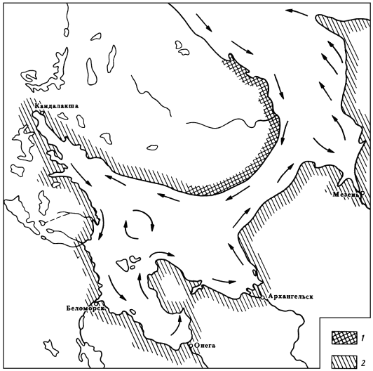
The waters of the White Sea rotate counter-clockwise, forming a huge whirlpool-gyroscope, which, precessing, reflects a tidal wave along the entire perimeter of the White Sea.
A similar pattern of tides and ebbs is observed in all lakes, seas and oceans.
http://tapemark.narod.ru/more/22.pngThe waters of the Mediterranean Sea rotate counter-clockwise, forming tides, 10-15 cm high. But in Gabes Bay, "what?" Off the coast of Tunisia, the height of the tides reaches three meters, and sometimes more, and this is considered one of the mysteries of nature. But at the same time, in the Bay of Gabes the whirlpool turns, precessing the reflecting additional tidal wave ?.
A tidal wave in the Amazon River creates a huge planetary maelstrom a few thousand kilometers in diameter, rotating between South America and North Africa, embracing the mouth of the Amazon River.
The scheme of motion of a tidal wave, along the perimeter of the North Atlantic planetary maelstrom. https://youtu.be/ZEhm_ONTQKcThe length of the tidal wave depends on the diameter of the whirlpool. And the height of the tidal wave depends on the speed of rotation of the whirlpool of the orbital velocity of the Earth, and the time of the tilting of the whirlpool (12 hours).
A = V1 • V2 / t
where: A is the amplitude of the tidal wave (precession angle).
V1 - rotation speed of the whirlpool.
V2 is the orbital velocity of the Earth.
t - the time of tilting of the whirlpool (12 hours).The vortex theory of tides can be easily verified from the connection of the height of the tidal wave with the rotation speed of the whirlpools. The height of the tidal wave can determine the location of the whirlpools. Drawing on a map of the depths and currents of the seas and oceans.
Continuation: Forum Faculty of Geography.
http://www.spbgu.ru/forums/index.php?showtopic=53992
The opening was published in the Russian-German scientific peer-reviewed journal "Eastern European Scientific Journal" No. 3/2015. 64. June
http://www.auris-archiv.de/journal.html A positive review was also received from the Institute of Geography of the Russian Academy of Sciences.According to the lunar theory of tides, the Earth's crust at the latitude of Washington, with a frequency of two times a day, rises with an amplitude of about 20 cm, at the equator, the range exceeds half a meter.
Then why, the highest tides are formed in the temperate zones and not at the equator?
The highest tides on Earth are formed in the Fandi Bay in North America - 18 m, at the mouth of the Severn River in England - 16 m, in the Bay of Mont-Saint-Michel in France - 15 m, in the mouths of the Sea of Okhotsk, Penzhinskaya and Gizhiginskaya - 13 m , at the cape Nerpinsky in the Mezensky Bay - 11 m.
The swirling theory of tides explains this inconsistency by the absence of whirlpools at the equator, as well as cyclones and anticyclones.
To form whirlpools, cyclones and anticyclones, the deflecting force of Coriolis is needed. At the equator, the Coriolis force is minimal and in the temperate zones, it is maximal.Tides and ebbs are formed not along the entire coast and the oceans, but only in those coasts where the high angular velocity of the currents (1-5 km / h).
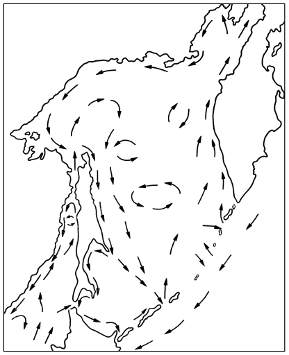
On the rectilinear coasts, where currents do not have angular velocity, tides and ebbs do not form.With an increase in the angular velocity of the current in the north of the Sea of Okhotsk, the height of the tides in the Penzhina Bay increases to 12 meters.
http://tapemark.narod.ru/more/41.png
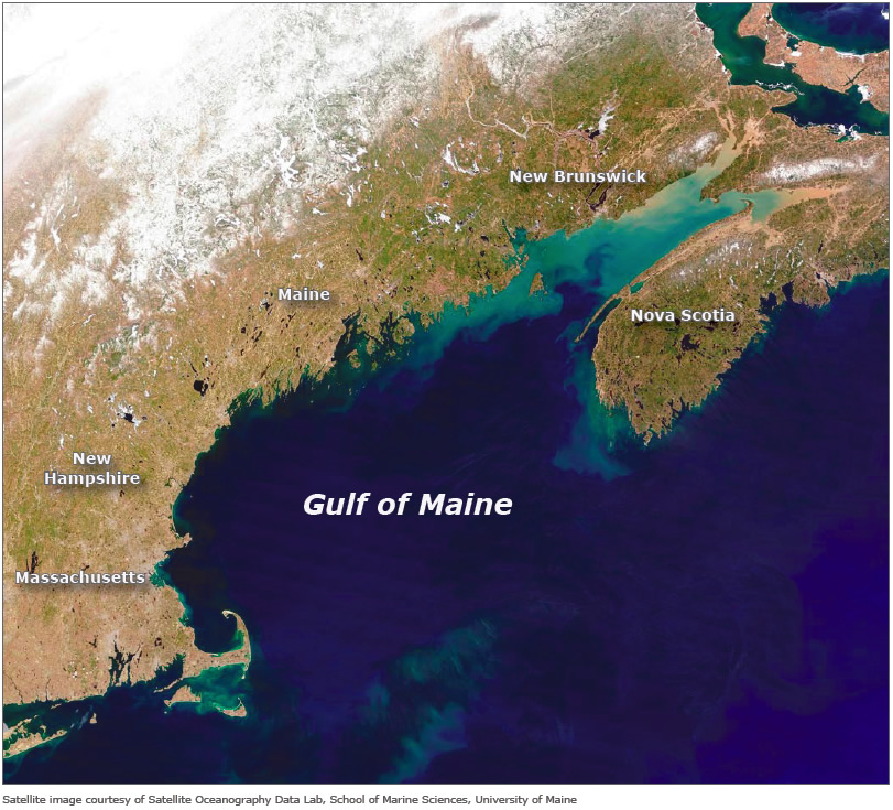
With an increase in the angular velocity of the current in the north of the Gulf of Maine, the height of the tides in the Bay of Fundy rises to 18 meters.
http://www.gulfofmaine-census.org/wp-content/images/circulation/fig4.jpg
"Record high tide in the Bay of Fundy - 21.6 meters - occurred only once in the history of observations, on the night of October 4 to October 5 in 1869 under the influence of the cyclone Saxby Gale" ..On the night of October 4 to 5, in 1869, under the influence of the cyclone Saxby Gale, "a record rainfall fell over the river basins flowing into the Bay of Fundy (300 mm in one day), so that the waters of the Bay of Fundy poured into the Gulf of Maine and increased the speed of rotation a whirlpool in the Gulf of Maine.
http://www.gulfofmaine.org/ebm/toolkitsurvey/images/exec-sum-2.jpg
Cyclone Saxby Gale rotating counter-clockwise, also contributed to the unraveling of the whirlpool.
In an abnormally cold winter and during a drought, when rivers flowing into the Bay of Fundy merge, the height of the tides does not exceed 1 meter.
https://www.tide-forecast.com/locations/Fundy-Offshore-1-Nova-Scotia/tides/latest0 -
The ebb and flow - the result of the Earth's rotation and whirlpools.
The discovery published in the Russian-German scientific journal "Eastern European Scientific Journal" №3. 2015. Positive review was obtained from the Institute of Geography, Russian Academy of Sciences..
The waters of lakes, seas and oceans of the Northern Hemisphere rotate counter-clockwise, and the waters of the Southern Hemisphere, rotate clockwise, forming giant vortices ..
It is known, what everything that rotates , including swirls have the property of retaining the gyroscope axis upright in space regardless of the Earth's rotation..
If you look at the Earth from the Sun, whirlpools spinning with the earth overturned, twice a day, making whirlpools precess and reflect on my own tidal wave around the perimeter of the sea..
The waters of the Gulf Maine waters are rotate counter clockwise to form a huge whirlpool, a gyroscope, which reflects the precessing tidal wave around the perimeter of the Gulf of Maine.
A similar scheme tides observed in all lakes, seas and oceans.-1 -
lnertial propuision
0 -
Bring to your attention, inertsioid functioning on the basis of the laws of celestial mechanics, showing the transformation of the orbital velocity of the Earth in the orbital velocity of the moon that does not give the moon closer to earth.
0 -
Reactionless drive url deleted per rule 2.7
0 -
Reactionless drive url deleted
0 -
The seasonal increase in water level of the seas and oceans.
Forum of the Institute of Oceanology
http://www.oceanographers.ru/forum/viewtopic.php?f=4&t=9249
The discovery published in the Russian-German scientific journal "Eastern European scientific magazine" №3 / 2015.
The discovery is also published in the scientific journal "Reports of independent authors" №33 / 2015.
Positive review and obtained from the Institute of Geography, Russian Academy of Sciences..
The waters of lakes, seas and oceans of the Northern Hemisphere rotate counter-clockwise, and the waters of the southern hemisphere rotate clockwise, forming a giant whirlpool.
The main reason for the rotation eddies are local wind ..
The higher the wind speed, the higher the rotational speed of whirlpools, and as a consequence, higher centrifugal force whirlpools, thereby increasing the water level of the seas and oceans.
The lower rotational speed of whirlpools, the lower the water level of the seas and oceans ..
The speed of currents at the perimeter of the seas and oceans is not the same everywhere and depends on the depth of the coast.
The shallow part of the seas and oceans for moving quickly, and in the deep seas and oceans for moving slowly ..
The seasonal increase in water level is not observed along the coast of the seas and oceans, and only in the coasts, where the high angular velocity of currents and as a consequence, high centrifugal force of water. (Centrifugal force F = mv2 / r).
On the straight coasts, where currents do not have the angular velocity, water level does not rise ..
Waters of the Gulf of Finland are rotated counterclockwise, forming a whirlpool in the form of an ellipse.
And when the south-westerly winds seasonal unleash a whirlpool of up to 5 km / h, increases the centrifugal force of the whirlpool, so that on the east coast of the Gulf of Finland the level of water rises to 30 cm.
A similar scheme is the seasonal increase in water level is observed in all the lakes, seas and oceans ..
The average depth of the Gulf of Finland is about 50 meters on the east coast about 5 meters to the west of the Gulf about 100 meters, for this reason, on the eastern coast of the Gulf of Finland, the linear and angular velocity of currents is much higher (much less than the depth of the coast, in the much improved flows speed ) ..
In the Gulf of seasonal increase in water level are two peaks in August and September, and in December and January and in time coincide with the season of the south-westerly winds.
The flow rate in the Gulf reaches from 2 to 17 km / h and a top speed of flow in the world is up to 30 km / h wind speed over 100 km / h.
http://esimo.oceanography.ru/esp1/index.php?sea_code=1§ion=6&menu_code=1734
Caspian Sea Water rotate counterclockwise, forming a whirlpool in the form of an ellipse.
And when seasonal winds and polovodnaya Volga River unleash a whirlpool, a whirlpool increases the centrifugal force, so that on the north coast of the Caspian Sea water level rise of 1 meter ..
The average depth of the Caspian Sea is about 200 meters, on the north coast about 5 meters, on the southern coast near the 700m.
In the Caspian Sea the peak seasonal increase in water level is observed in June-August, and will coincide with the season of winds, and floods of the river Volga.
http://tapemark.narod.ru/more/06.png
In season westerly winds flow velocity along the coast of Murmansk in the Barents Sea increased to 5 km / h, thus, a seasonal increase in water level reaches 0.5 meters.
The maximum level observed in October - November, minimum in April-May.
http://proznania.ru/?page_id=2353
In the Bay of Bengal during the monsoon season winds whirl speed increases to 10 km / h, thus, a seasonal increase in water level reaches 1.2 meters.
http://www.aziya-tur.ru/bengal%27skii-zaliv.php
Seasonal changes in the Okhotsk sea level is 0.2-0.5 m highest level of values recorded in November and January, the lowest in March -. April.
http://parusa.narod.ru/bib/books/fareast/1406-1.htm
The seasonal increase in the level of the Black Sea (40 cm) is best expressed in the southeastern part of the sea, where the angular velocity of currents in the summer reaches its maximum value.
http://tapemark.narod.ru/more/07.html
The assumption that the cause of the seasonal increase in water level can be the pressure of the atmosphere, river flow, temperature difference and salinity of the water does not hold, these factors can increase the level of water a few centimeters. But no more.
Cyclones moving over the surface of the sea from west to east at a speed of 40 km / h can be for a few days to increase the level of the sea, whirling maelstrom.
http://www.okeanavt.ru/tainiokeana/1066mifosrednemurovne.html
Representation theory can be easily checked by the communication speed flows with the level of the seas and oceans.
(Based on the depth map and the currents of the seas and oceans).
Continued: Forum MEPhI
https://mephi.ru/communication/forum/talk/forum13/topic5498/messages/
0
Vortices from earth rotation (split from Tides)
in Speculations
Posted